Tasmania is one of the most beautiful places to visit in Australia, the entire island is rich in history as well as natural beauty.

We spent almost 3 months exploring Tasmania, experiencing all that the island could offer us. Below we have listed our favourite and most photographic locations in Tasmania to add to your wishlist.
Cradle Mountain-Lake St Clair National Park (Dove Lake & Lake St Clair)
Cradle Mountain is one of Tasmania's most well known landmarks and most visited national parks. We knew it would be beautiful from the research we had done prior to traveling to Tasmania but were floored when we got to see it in person.
The Cradle Mountain-Lake St Clair National Park is located in Central North West Tasmania, around 2 hours west of Launceston.


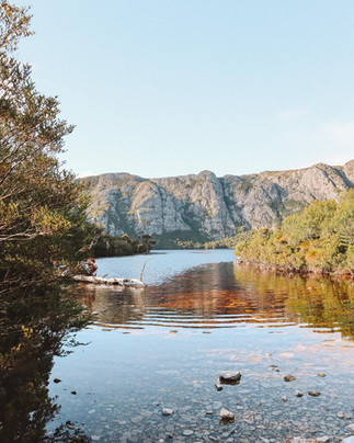


In the north the distinctive mountain towers above Dove Lake and is one of the most popular photography spots in all of Tasmania. The best photos we found were early morning or late evening on a calm, clear day, where the mountain is reflected in the lake's surface. Another photographic spot is the old boat house down at the lakes edge, partway round the lake circuit.
Lake St Clair in the southern part of the park is one of the largest freshwater lakes in Tasmania. The pumping station that sits on the lake's south eastern edge makes for a beautiful photo at sunset, when the water is still it perfectly conveys the peacefulness and tranquility of the area.


If you want to know more about the walks and hikes in Cradle Mountain national Park, or where to find wildlife, you can read our blogs here: A Week Exploring Cradle Mountain National Park
Bridestowe Lavender Estate
After gaining popularity on Instagram, Bridestowe Lavender Estate is one of Tasmania's most popular attractions to see. Located in the states north east, the estate is around 1 hour north east of Launceston.
Whilst the pictures on social media may look stunning, keep in mind that the lavender farm has a seasonal growing period and harvesting period. Outside of these seasons, the farm will not look like the pictures you see on Instagram. The growing period of the farm is spring through to summer; and can be harvested anytime from mid January to mid February, however normally most of the harvest will be done by the end of January, so keep this in mind when planning your visit.
It is a $20 entry per person to the estate which the staff collect at the door. (which in our honest opinion is pretty steep, especially because the food at the cafe is not cheap either) The classic photo to get here is one wandering through the rows of lavender plants in a crisp white dress, or holding a purple ice cream in amongst the lavender plants. We did not get either of these photos, but take a look at Instagram to get an idea.
Whilst a photo here may be on your Tasmania wish list, make sure you plan to visit before harvesting period otherwise you will potentially be disappointed when you arrive at the lack of lavender.
Tasman Peninsula Cliffs (Cape Hauy, Raoul and Pillar)
Boasting the tallest ocean cliffs in the southern hemisphere, the Tasman peninsula has many incredible photography locations. The Tasman National Park, which makes up a good portion of the peninsula is where you can find 3 of the most striking cliff landscapes in Australia.
Cape Hauy, Cape Raoul and Cape Pillar are the big 3 places to check out when you are exploring the Tasman Peninsula. Each cape is unique in its own way and should be experienced from multiple angles in order to truly take in these geologic marvels. The 3 capes are located at different points along the Tasman Peninsula coastline, in order to get to them, you either need to hike to them, catch a scenic flight or take one of the scenic cruises around the peninsula.


We undertook 2 of the hikes and took a scenic cruise in order to see Cape Pillar. The hikes for both Cape Hauy and Cape Raoul are moderate to hard and will take several hours to complete depending on your ability. Cape Raoul is a 14km return hike which took us slightly over 5 hours to finish. The hike takes you through the forest of the national park to get to the top of the cliffs at the top of the cape. From here you follow the cape down in elevation until you get to the very tip of the cape, at this end point there are several lookouts to view and photograph the jagged tip of Cape Raoul.
Cape Hauy is a 9km return hike that took us around 4 hours to finish. This hike is very challenging as the walk to the tip of the cape goes through very large changes in elevation, at the end of the hike you will have climbed over 500m! Despite the difficulty, the reward at the end of the hike is the stunning view of two amazing rock formations; the Totem Pole and the Candlestick. As the names would suggest these two rock structures are large vertical dolerite columns sitting out in the ocean at the tip of the cape, and were formed by the erosion of the cape over hundreds of millions of years.


Lastly Cape Pillar is the one hike we did not attempt, it is far more isolated than the other two hikes and is only accessible by the Three Capes Track. It will take around 4 days to complete the 48km track but at the end you are able to stand on the highest ocean cliffs in the southern hemisphere. The Blade is the prominent rock formation at the tip of Cape Pillar and is the end point for the Three Capes Track.
An easily way to see the Blade and Cape Pillar is from the ocean, there are a couple of different tour options for scenic boat cruises around the Tasman Peninsula, we chose Pennicott Wilderness Journeys. The day we had our cruise was extremely good weather and we were able to take a rare detour to also see Cape Raoul, something that normally isn't possible due to rougher waters on the western side of the peninsula.
The cruise then takes you around the southern and eastern edge of the peninsula where you pass between Tasman Island and Cape Pillar. From the ocean you are truly able to take in the scale of the Blade and the sheer size of these cliffs, ensuring you have your camera ready will allow you to get the perfect shot. You will then head up the eastern coast of the peninsula to Cape Hauy, here you will be able to get an amazing shot of the Candlestick and of the Totem Pole. The cruise will also take you through several sea caves if the weather permits it, again this is a unique photo opportunity that is not possible if you do not do the cruise.
Whilst the Capes can be photographed on foot by hiking there, we found that the best place to capture the amazing cliffs was from the water and we cannot recommend Pennicott Wilderness Journeys enough. There are also many other photographic places on the Tasman Peninsula that is worth the visit, such as the Tessellated Pavement, Port Arthur and Stewarts Bay.
Mount Wellington (Summit)
Mount Wellington is one of the largest mountains in Southern Tasmania, this mountain is an impressive backdrop located behind the capital city of Hobart.
There is a narrow winding sealed road that allows you to drive all the way to the summit, with multiple lookout points on the way up. The drive is incredibly scenic and one of the best things to see and do in Hobart.
Your trip up the mountain is highly dependent on weather however, for most of winter and spring the mountain is covered in snow, through autumn and even summer if it is cold enough the summit will sometimes be covered by a thick fog. The benefit to the mountain being so large is you can see it from almost anywhere in Hobart, so it is quite easy to see if you will be able to have a good view from the top or if it isn't worth it on that day.


We found one of the best times to go is before sunrise, on very good and clear days, the cloud level will be below the peak of the summit. This allows for a unique photo opportunity where you are standing on a rocky outlook appearing to be above the clouds! At other lookouts you are able to get wide landscape shots of Hobart and the Town of Kingston to the South of Hobart.
If the weather isn't perfect when you are traveling through Hobart, we recommend making the time to visit the summit regardless. The drive is lovely and not very far from the CBD and you will still be able to walk around the summit, visit the observation deck or complete some of the bushwalks that leave from the summit.


Secret Staircase in Corinna (Lovers Falls)
Probably one of our favourite photos that we have taken on this trip is of the staircase to Lovers Falls in Corinna. We hadn't initially planned on going to this location, but after visiting the visitor center in Strahan on Tasmania's west coast, we noticed a photo on a book of a wooden staircase descending from a forest into a river. We asked the staff about it and they told us that you could find the location in Corinna.
We did a bit of research on the location of this waterfall and found it's in a very remote section of Tasmania, located on the Pieman river, Corinna is at least an hour from the nearest Town. The small village is so small that it technically has a population of 0 as they count the people living here as living in Waratah, a major town an hour to the east. It is in such a remote part of Tasmania that there is generally no Wi-Fi or phone signal through the town, when visiting locals generally tell you to make sure you start your GPS when you leave Waratah or Zeehan as once you leave those two towns you won't be able to access your map information until you return.
Not many people live in the small village as the main attractions come from the wilderness eco retreat and the different river cruises that operate through the area. Lover's falls is one of the main attractions to see, however it is inaccessible by car or foot and only by water. It is approximately 5km downstream from Corinna and can only be accessed by one of the boat cruises or hiring a kayak/canoe and paddling there yourself. It is a difficult paddle if you choose that option, however you are more likely to have the place to yourself and not contend with others on the cruises.

Once you arrive at Lovers falls you are greeted by the mysterious staircase that descends from the forest into the water, the falls themselves are a short walk along a wooden boardwalk, there are some stairs but nothing very difficult. Try to plan your visit after heavy rain or after the winter season as that is when the falls will be the fullest, we unfortunately saw them during a drought where it was more of a trickle of water instead of a full waterfall.
It is quite far out of the way but if you enjoy adventuring through the wilderness, you should definitely add this photographic spot to your list for your next Tasmanian adventure.
Mount Field National Park (Russell Falls and Tall Trees Walk)
One of the other national parks that make up Tasmania's Wilderness Heritage Area, Mount Field National Park is one of our favourite locations in Tasmania. Located about an hour and a half west of Hobart there are so many amazing things to see and walks to do in this park.
The highlight of the park is Russell Falls, a 58m tall, two-tiered cascade waterfall. It is utterly stunning when it is fully flowing and allows for some amazing photos. There are multiple viewpoints around it to allow you to capture different perspectives and also try out some motion lapse photography.


The falls are a short walk from the carpark and visitor centre but also the start of the three falls walk. This walk is a longer hike at 6km in length but will take you to the three waterfalls in the park and through some of the best rainforest in Tasmania. After Russell Falls, the walk will take you up the hill above the falls and across the stream to the second waterfall; Horseshoe falls. Much more dependent on rainfall, Horseshoe falls are at their best after a heavy rain event.
After Horseshoe falls the walk winds you through the forest where you can complete an optional short circuit; the Tall Trees Walk. This short circuit is only 1km and will only add another 30 minutes onto the falls circuit walk.
The loop takes you through a section of swamp gums which are some of the tallest trees in Australia. This section of the forest makes for some excellent photo opportunities, the thick forest canopy allows minimal light in and creates a very moody atmosphere for photos. Capturing the scale of the trees with a person standing next to them also makes for an excellent shot.


The hike continues to wind its way down through the forest until you reach Lady Barron Falls at the bottom of the valley. Tucked away this waterfall is framed by fern trees and rarely visited compared to the more popular Russell Falls. The hike back to the visitor centre will have you walk alongside the river before climbing a large set of stairs back into the forest. The hike should take around 2 hours to complete, 2 and a half if you complete the optional Tall Trees walk, and has many photographic points along the way.
This is just the main walk from the visitor centre, the park has many other walks and photo opportunities to take advantage of. In our opinion it is one of the most scenic places in Tasmania and we highly recommend visiting the park if you are exploring the area around Hobart.
Montezuma Falls
The tallest waterfall in Tasmania had to make it onto our list, the scale of this waterfall cannot be described accurately without seeing it in person. Located in Tasmania's Western Wilds, Montezuma falls has a drop of 110m and is only 15 minutes from the nearby town of Rosebery.
The hike to get to Montezuma Falls may look intimidating on paper however it is one of the easiest long hikes that we have done on our travels. It is 10km return and will take around 3 hours to complete depending on how long you stay at the falls. The track itself is almost flat as it follows an old mining rail track, with a slight uphill grade on your way to the falls you will find the return walk even easier as you notice the downhill slope.
The waterfall itself is extremely impressive, it is a horse tail waterfall, meaning it has a narrow chute of water from the top of the falls that fans out like a horse's trail near the bottom. Due to the volume of water coming over the top of the waterfall it is extremely powerful by the time it has reached the bottom of the falls. You can feel and see this power, with the wind generated by the falling water moving the trees around the base and blowing into your face. Even during the dry season there is a considerable amount of water and force coming from this waterfall. After periods of heavy rain, this waterfall is much more powerful and impressive, the water spray from the falls can be felt from the suspension bridge out over the river which is around 30-40m away from the base of the falls.
There are many different photo opportunities along this hike, from the peaceful walk through the forest along the old rail line, passing by old wooden bridges and tunnel spurs that were dug, to the waterfall itself and the suspension bridge that takes you out over the river for a vista viewing platform of the waterfall. When visiting Tasmania be sure to add this to your list as it won't disappoint.


Bay of Fires (The Gardens, Binalong Bay, Suicide Beach)
Probably Tasmania's most well known scenic spot behind Cradle Mountain is the Bay of Fires on the Eastern coast. Its name came from the English navigators who saw the fires from the local Aboriginal tribes on the beaches as they were exploring Tasmania in the late 1700's. Stretching for around 50km, the bay begins in Binalong Bay in the south, near St Helens, and reaches up to Eddystone Point in the North.
Nowadays the area is one of Tasmania's favourite tourist destinations, known for its crystal blue water, white sandy beaches and orange lichen-stained granite boulders that dot the beach landscape. Having heard and seen photos of this area it was one of the Areas in Tasmania we were most looking forward to.

And we were not disappointed, the beaches were stunning, the water was amazing and the different colours of the rocks and bush surrounds set the scenery apart from any other beaches we have seen in Australia. The main areas to explore that are advertised to tourists are Binalong Bay, the main town in the region, and The Gardens, a small collection of holiday houses stretching out in the central section of the bay. Whilst these areas are lovely, we found exploring smaller lesser known and sometimes secret beaches to be better. And we found so many photographic locations in doing so.


Suicide beach, is one of the smaller beaches to the south of the main Gardens area. Here we found the perfect setting for a rockpool, as well as many other well framed spots amongst the large granite boulders. There are also several small coves around skeleton bay which is just east of the main Binalong bay beach area. These small coves again had small rock pools and were very sheltered from the open ocean meaning that they were perfect for swimming in the shallow water.
Lastly, one of our favourite spots was Swimcart beach, where you can camp for free right in the sand dunes, less than 10m from the water! It was a perfect campsite to watch the sunrise over the ocean and go for walks along the white sandy beach.


Wineglass Bay
Probably runner up for Tasmania's most scenic location, Wineglass Bay is the star attraction of Freycinet National Park on Tasmania's central east coast. The National park is just outside of Coles bay, the small local town and is around 2 and half hours from both Hobart and Launceston. As you approach Coles bay a distinct feature on the horizon appears; The Hazards, the mountain range that the park is famous for, these 3 peaks are almost 500m and very imposing with how sharply they rise out of the Ocean.
It is a decent hike to get to the lookout for Wineglass bay, as you need to climb the saddle of the Hazards in order to cross from the west side of the peninsula to the east to view the bay. The hike is not overly long but the sharp rise in elevation makes this hike moderately difficult.
From the lookout you can see across Wineglass bay and the rest of the Freycinet peninsula, after the lookout you can choose to return to the carpark or start several of the longer hikes through the National park. You can walk down to Wineglass bay and loop around the peninsula via Hazards beach for a longer 14km return hike, or complete the Freycinet peninsula loop, a 30km return hike that follows almost the entire peninsula coastline.
Whether you are there just to get a photo of Wineglass bay, or attempt the intimidating Mt Amos summit climb, there are many beautiful locations in the Freycinet national park to see. Make sure to add this to your places to visit when planning your next holiday to Tasmania.


Gordon River Dam
Probably one of the lesser-known places on this list, the Gordon River Dam is located at the end of Gordon River Rd, the only road in the South West Tasmanian Region. The South West of Tasmania, is sparsely populated and the majority of it is National Park, protected as part of the Tasmania Wilderness World Heritage Area. It is quite far away from major population centres, being 2½ hours one way from Hobart, because of this, the region is very rarely visited by tourists aside from those intrepid adventurers looking to hike in the National parks of the region.
The dam was built in 1974 and produces around 13% of Tasmania's electricity supply from the hydroelectric plant at its base, the construction of the dam led to the nearby flooding of Lake Pedder, making it one of Tasmania's largest freshwater lakes. More recently the dam has become more popular due to the viral YouTube video of the highest basketball shot. In 2015 How Ridiculous broke the world record for highest basketball shot by shooting off of the top of Gordon dam and sinking a basket at the bottom.
The dam itself is the tallest dam in Tasmania and one of the tallest in Australia, because of its height and location in the narrow Gordon River valley, it is quite a unique photographic location. We found on clear, calm days near sunset, you could get a wonderful photo of Lake Gordon behind the dam. You could also see on the sides of the lake where the dam's peak level has been in the past due to changes in the vegetation on the sides of the mountains.


The Neck, Bruny Island
Lastly on our list is one of the most unique places not only in Tasmania, but also in Australia. There are not many places that have the unique geography where you can stand and look over the ocean to both your left and your right, this is The Neck located on Bruny Island.
Bruny Island is one of Tasmania's largest islands, and is located off the south coast of Tasmania, near Hobart. You can catch a ferry across to Bruny Island from the port at Kettering which is around half an hour south of Hobart. You can stay and explore the island, with different accommodation options from camping to resorts and b&bs. There are many tourist attractions to see and the island is home to the incredibly rare, Albino Wallaby, which only exists on Bruny Island as there are no predators that live here.
The most famous attraction on the island is The Neck, a narrow isthmus made of sand that connects the two sections of South Bruny and North Bruny together. The western side of the neck is Great Bay whilst the Eastern side is Adventure Bay and the Tasman Sea. A large staircase leads you up to a lookout that provides an almost 360-degree view of the island and the two bays either side, here you can take the perfect photo of looking south down The Neck.
Made popular more recently with the increase of tourists visiting and sharing photos on Instagram, Bruny Island should definitely be added to your list of places to visit. Not just for the photo of The Neck but also a chance to spot the rare Albino Wallaby as well as the many other beautiful bays and beaches located around the Island.


Comments